The Santa Barbara County Independent Redistricting Commission drew a final county map during its Dec. 4 meeting.
This meeting marks the end point of a year-long journey to redraw Santa Barbara County district lines that align with the 2020 Census Data as well as highlight communities of interest, such as renters and the Latino voter population. The new boundaries will remain intact for the next 10 years, and this map impacts the county voting population distribution.
“We’ve spent five to six months gathering information from the public, and we are going to continue doing that today,” Commissioner Glenn Morris said. “The ordinance puts the responsibility for drawing the final map on the commission, and it’s our turn. That may lead to an adoption of one of the three maps presented, or minor or substantive changes on a map.”
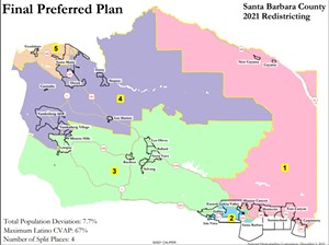
The final preferred map—altered from current district lines—puts the Cuyama Valley and the water basin in the 1st District, splits Goleta between the 2nd and 3rd Districts, keeps the Santa Ynez Valley and part of the coastline in the 3rd District, keeps the city of Lompoc in the 3rd District, puts Vandenberg Space Force Base in the 4th District, and has Guadalupe with Santa Maria in the 5th District.
The commission used Map 822 as a template because of its low population deviation, and pulled elements from other maps—like Cuyama being in the 1st District—to respect community wishes and meet a compromise as commissioners.
“We can take elements of [one] map and apply them to another; this is an opportunity for us to apply what we have learned,” Morris said.
Santa Barbara County residents expressed opinions both for and against this map. At the meeting, county resident Amy Blair said she was pleased with the outcome.
“I’m happy we came up with a compromise and have everyone’s voices heard and represented in Santa Barbara County. We stuck communities of interest together, we may not have made everyone happy, but it’s a damn good compromise,” she said.
Mayor of Lompoc Jenelle Osborne was grateful for Lompoc remaining together but was concerned about Vandenberg Space Force Base.
“I do appreciate keeping Lompoc whole, but [I’m] disappointed that we were not lumped in with the Vandenberg area. Instead, we were considered all ag. We’re not all ag, we’re not all retirees, we are a town of 44,000,” Osborne said.
Current district boundaries include Lompoc and Vandenberg within the 3rd District, and they historically have been included together for city and county issues.
Resident Carol Redhead appreciated the map, and believes it represents the county well.
“I remember the mayor of Santa Maria and the people of Guadalupe wanting to be together. I’m so glad most of Lompoc is in [District] 3 with the huge [agricultural] areas of Los Olivos, Ballard, Solvang, and Buellton. I’m so glad the 55,000 single renter students of UCSB are no longer a part of District 3. It’s a good compromise,” Redhead said.
This map is not finished yet; the final map will be selected on Dec. 8 at 6 p.m. after the commission discusses any tweaks—if necessary—and gets a data analysis from the National Demographics Corporation. The absolute deadline for map adoption is Dec. 15.


